Cranleigh Urban
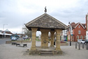
Cranleigh Fountain
Photographer:
N Chadwick (cc-by-sa/2.0)
Type of course: Virtual Terrain type: Urban
Overview
Our Cranleigh urban course covers a good proportion of what is said to be the largest village in England. The Crane on the Fountain Memorial is a reminder of when the area was noted for craneries (cranes being a great delicacy) - hence the name Craneley or Cranleigh as it later became.
Location Info
/-0.4876,51.1399,12/500x400?access_token=pk.eyJ1IjoicGF1bGZyb3N0IiwiYSI6ImNra2IwMTBmYjAycTMzMG9jd21vbHU5MTgifQ.rqFOKAS1eZHXRYlSb6G62g)
Near: Godalming Lat,Lng: 51.1399,-0.4876 Postcode: GU6 8AE What3Words: ///mango.silly.commuting
Open an interactive map in: GoogleMaps - AppleMaps - OpenStreetMap - BingMap (OS 50k)
Directions / Parking
Parking is at the Village Way Car Park (GU6 8AF), by the Leisure Centre. Parking charges are currently £1.70 for 2 hours (between 08:00 - 18:30, Mon-Sat).
Courses available
MapRun directory path:
UK/Surrey/SW Surrey/Cranleigh Urban v1
General Info
This is a 60 minute score course with 40 controls and a penalty of 10 points for each (part) minute over. Cranleigh is flat, so you don't need to worry about the contours on the map! It's at 1:10000 scale in Street-O style, with different colours to the traditional orienteering maps - the key difference is that white means no access unless clear on the ground.
The "Map" link below gives you an A4 (Landscape) pdf, Control Descriptions and Safety Notes are included as the 2nd page of the map.
The Start and Finish is just outside the Leisure Centre Entrance.
When you pass the Finish control, then it will stop the timer, once you have started and found at least other control.
Safety Notes
- The course has been created from Open Street Map - we can't guarantee that a route shown on the map is a legitimate right of way - please keep to public roads, paths and open spaces.
- There are paths marked on the map as "indistinct" in the area between Controls 30, 33 & 38 - please pay careful attention here!
- When running the course please be aware of residents / town centre users / walkers - maintain social distancing and give way if necessary. Please follow the applicable government COVID-19 restrictions and the British Orienteering Covid Guidance.
- This course is located in Waverley, Surrey. Please consider current Covid-19 restrictions. You should check current government rules for yourself as to whether this activity is permitted – don’t forget that your name will be shown in the MapRun results!
- You are responsible for your own safety - this has NOT been registered as an event with British Orienteering and is not covered by their liability insurance.
- You will need to cross many roads, some busier than others - check for traffic before you cross! For this reason, under 16s MUST be accompanied by a responsible adult.
- Cranleigh High Street and main roads can be busy at times, please use the pelican / zebra crossings to cross - these are marked on the map.
- Due to Covid-19 restrictions, the Cranleigh Cemetery is Out of Bounds.