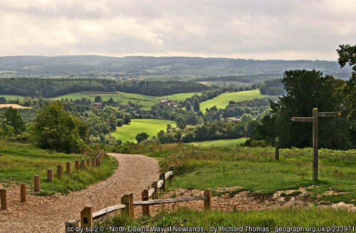
Newlands Corner
Type of course: Virtual Terrain type: Woodland & Forest
Overview
We have 2 "virtual" courses available from Newlands Corner - the Yellow course is suitable for all ages as it keeps within the Newlands Corner area not crossing any roads. The other is a much longer Trail Run to St Martha's which has a number of road crossings. Newlands Corner lies on the chalk ridge of the North Downs in an Area of Outstanding Natural Beauty (AONB) giving good views south across the Weald.
Location Info
Near: Guildford Lat,Lng: 51.2329,-0.5076 Postcode: GU4 8SE What3Words: ///remark.sleeps.stamp
Open an interactive map in: GoogleMaps - AppleMaps - OpenStreetMap - BingMap (OS 50k)
Directions / Parking
Parking is at Newlands Corner Car Park, (GU4 8SE) off the A25 Shere Road, SE of Guildford. There are no parking charges but it can be busy.
Courses available
MapRun directory path:
UK/Surrey/SW Surrey/Guildford Newlands Corner
General Info
On its wooded northern Newlands Corner is also a great place to spot for yew trees - you'll rarely see so many large yews in such a small area with 129 ancient specimens recorded (at least 500 years old - and some probably at least 1000 years old). It's close to Guildford and the A3, just off the A25 with a cafe and free parking, but can be busy so time your visit carefully!
Yellow Course
The map is at 1:5000 scale and is similar to a traditional orienteering map but with white denoting any type of woodland (rather than the usual green on an Ordnance Survey map); we are intending to have a choice of courses, but for the moment there's just one which is suitable for beginners.
The course is the same as controls 1 - 9 of our permanent course
With line courses, all the controls must be visited in the correct numerical order i.e. 1, 2, 3 etc (or else MapRunF will report "MisPunch" when you get to the end). Don’t worry if you accidentally visit a control before you should have, just make sure you visit that control again in the correct numerical sequence.
St Martha's Trail Run
The circular route heads northwest into the woodland, then along the North Downs Way aka Pilgrim's Way to St Martha's Hill returning via Pewsey Down. It's mostly bridleways so there should be plenty of space to social distance, but you might come across some cyclists as it includes part of Cycling UK's 150 miles North Downs Way route.
On the way you reach St Martha's Church, with the original structure dating from the 12th century, although rebuilt in the 19th century. There are 10 controls to guide you on the way. Navigation won't be too difficult as the MapRunF app will show your track and current position.
The map is at 1:15000 scale and is similar to a traditional orienteering map but with white denoting any type of woodland (rather than the usual green on an Ordnance Survey map).
Although the map shows the Start and Finish at Newlands Corner, you can start anywhere on the route (but you must finish at the same control). This may be more convenient for you!
Once you get to the Finish control, MapRun will check the controls you have visited, calculate your results and then upload them. You will be able to compare your run with others – just select the “Results” link below for the course you ran. The “Tracks” link will show the actual track you took (and other participants’).
It is easier to follow a printed map - the "Map" link gives you an A4 (Landscape) pdf to download - if you print it out 'Actual Size' then the scale will be correct at 1cm = 50m. Control Descriptions and Safety Notes are included on the Map.
The Start on the pdf map is at the far western end of Newlands Corner Car Park - where there's white hatching on the carpark and a footpath heads north west into the woodland.
The Finish on the pdf map is close to the start, but on the south side of the Car Park and is marked by an Orienteering Finish Post. When you pass the Finish post, then it will stop the MapRun timer, once you have started and found at least one other control.
If you enjoyed these courses then you might also be interested in our Petworth Park Virtual courses.
Safety Notes
- The course has been created from Open Street Map - we can't guarantee that a route shown on the map is a legitimate right of way - please keep to public roads, paths and open spaces.
- When running the course please be aware of horse riders / cyclists / walkers - maintain social distancing and give way if necessary. Please follow the applicable government COVID-19 restrictions and the British Orienteering Covid Guidance.
- The St Martha's Trail Run crosses narrow lanes, none are usually busy - check for traffic including cyclists before you cross. Under 16s should be accompanied by a responsible adult.
- This course is located in Surrey. Please consider current Covid-19 restrictions. You should check current government rules for yourself as to whether this activity is permitted – don’t forget that your name will be shown in the MapRun results!
- When encountering horses, approach carefully and don't startle them - make sure they can see you clearly.
- Newlands Corner is popular with cyclists - be alert to mountain bikes on the trails, there won't be much warning of their approach!
- On the course you will encounter many yew trees (Taxus baccata) - all parts of this tree including berries and leaves are extremely poisonous (to humans and dogs) !
- You are responsible for your own safety - this has NOT been registered as an event with British Orienteering and is not covered by their liability insurance.

/-0.5076,51.2329,12/500x400?access_token=pk.eyJ1IjoicGF1bGZyb3N0IiwiYSI6ImNra2IwMTBmYjAycTMzMG9jd21vbHU5MTgifQ.rqFOKAS1eZHXRYlSb6G62g)